

Naver is to Korea what Google is to America. It’s the go-to search engine and directions provider. And as far as mapped-out bike paths are concerned, Naver and Korea are both way ahead of the game. While it can be intimidating to stare at a screen filled with Korean words (there is no English setting, sorry), it’s actually still very possible to navigate. Here’s how:
To find a bicycle path near you:
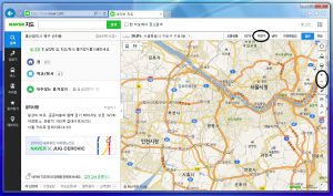
1. Go to Naver Maps and zoom in on your desired location. Move about the map by clicking, holding and dragging. To zoom in and out, use the + / – feature placed vertically on the righthand side of the screen.
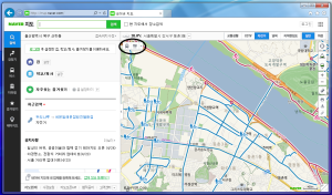
2. In the same menu bar as the little weather symbol/info (directly above the map portion of the window, perpendicular to the zoom feature), you’ll see a list of options to the right; the first three of which are: 교통상황, CCTV, and 자전거. “자전거” means “bicycle,” so click on that (the third option, directly to the right of CCTV).
3. This will bring up all bike paths in the vicinity! Purple lines denote paths that are strictly for bicycles. Blue lines signify paths that are for both walking and riding.
To calculate distances along bicycle paths:
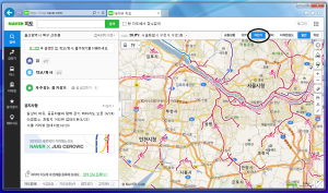
1. Assuming you are staring at a Naver map and have the bicycle path option turned on, right click on your starting location. This should bring up a small menu with three options at the top.
2. The leftmost option means “start.” Click that to establish your beginning point.
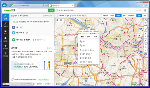
3. If you want to set a midway point, right click again on your next spot. Select the center option. You can set up to five midway points, but actually they’re not necessary at all if your only concern is the distance from point A to B.
4. To set your finishing spot, right click and select the rightmost option.
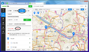
5. Naver will automatically calculate time and distance for you. BUT, to make sure it is following bicycle paths only, there is one more step.
6. To the left of the map portion of the window, you’ll see a menu with 4 transportation options. Select the little bicycle icon. Partway down the same menu, you’ll see some red numbers and text. The number on the right is the approximate distance in kilometers based exclusively on bike path routes.
To find food near a location:
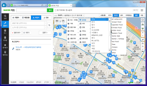
1. When looking at your desired location, and with the bicycle paths in the area revealed, you will see a bus and food symbol directly below the weather bar (upper left corner of the map). Hover over these icons to expand the menu.
2. The top option![]() in the right column, the fork and spoon, is for food. When clicked, it will automatically reveal all restaurant options in the area*. But if you’ve got a hankering for something specific, you can narrow your search!
in the right column, the fork and spoon, is for food. When clicked, it will automatically reveal all restaurant options in the area*. But if you’ve got a hankering for something specific, you can narrow your search!
3. Click on the food icon again to bring up a new submenu directly to the right. From top to bottom, the options are as follows:
To find lodging near a location:
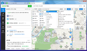
1. Hover over the bus/food icon. In the right column, click on the second option from the top (the little person in the bed).
2. Similar to the food search, you will automatically be presented with all lodging options*. To find a specific kind of accomodation, click on the lodging symbol again to bring up the submenu.
3. The lodging options are as follows, from top to bottom:
*Sometimes if you’re too zoomed out, it won’t show anything when you’re searching for food or lodging. It also may take you a short distance away from your preferred location because there simply aren’t any restaurants/places to stay where you were looking.
Hope this was helpful!

To view the original post and other great content, visit Korealizations at:
http://korealizations.wordpress.com
Like Korealizations on Facebook and subscribe on YouTube! Thanks for reading!
Recent comments