

Name: Mt. Gaji
Time: 5 hours (rounded down so I feel better about myself)
Distance: 13 km (rounded up, for the same reason)
Difficulty Rating: Totally awesome but also pretty freakin hard and exhausting, yet not impossible for a newbie in tennis shoes


Today I hiked Mt. Gaji, the highest peak in Ulsan! At 1,290 meters, the summit offers stunning panoramic views of the Yeongnam Alps and is also one of the famous “Ulsan 12″ (the 12 scenic sites of Ulsan).
My friend, Taylor, and I left our neighborhood in Ulsan at 10:00 AM. From there we bounced, jerked, and jolted around on the bus for an hour and a half until we arrived at the base of the mountain. Before beginning our ascent, we briefly wandered through a temple. Then, it was onward and upward! … For a little over three hours.
Right from the start, the going was steep enough to leave us huffing and puffing between bits of conversation. At first we didn’t see too many other people on the mountain. But as we got closer and closer to the top, it started to rain Korean hikers. Very well dressed Korean hikers, complete with hats, walking sticks and gloves. Every now and then we’d pass a small gaggle of them enjoying a quaint little mountain-side picnic. A few of them even offered to share their food with us! More often than not, though, our interaction with them consisted of minimal eye contact and mumbling “Annyeong-ha-sey-yohhhh,” “nehhhhh,” between heavy inhales and exhales. A few times, with some of the hikers closer in age to us, I encouraged them by pumping my fist and enthusiastically saying, “Wai-ting!,” which is their way of saying “Let’s go!” or “You can do it!” That usually got a smile and a laugh.
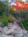
The trail itself wasn’t particularly well-marked in terms of frequently-posted signs or helpfully-paced ribbons. But it was rather apparent that there was only one path, and one direction: up. Up and up and up and up. At several points the terrain left us no choice but to hoist ourselves along with the assistance of these awesome, heavy-duty ropes. And when there wasn’t a rope, it was time to do some amateur rock climbing. Fair warning #1, if you don’t like walking along narrow pathways flanked by unforgiving drop-offs and skinny trees, where the guard rail/ropes are few and far between, you might want to think twice before hiking Mt. Gaji.

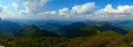


It took us about 2 hours to reach the ridge line, and it wasn’t until about an hour later when we reached the summit that we had any sort of real view. Once or twice we stumbled upon a lookout point, but the scenery was by far the best at the top, obviously! Taylor and I celebrated our conquering of Mt. Gaji with a Choco Pie or two, and we made damn sure to take plenty of pictures, including one with the altitude sign.
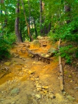
Going down we took a different way, in order to make a “loop” out of the trip. It was at this point that we acquired a new appreciation for those silly walking sticks everyone else seemed to be using. See, back in Michigan, where the land is nothing but flat, flat, flat, if you went anywhere with walking poles you’d either look absolutely ridiculous, uber pretentious, or both. But here, those things are literally life savers. While Taylor and I were busy clinging to ropes, tree trunks, branches, large boulders and anything else we could use to prevent us from plummeting to our deaths, all the Koreans blew past us with such ease and effortlessness, as if they were prancing on a cloud. Seriously, we couldn’t even hear their feet hitting the ground. Just the gentle click-clack of their poles momentarily skewering the path. Meanwhile, we’re eating their dust and causing mini rockslides as we slipped and stomped our way to the bottom. Fair warning #2: the hiking path is a healthy mixture of packed dirt, streams of loose rocks ranging from 2″ to 12″ in diameter, and boulders. A few times we came across some man-made stairs (both newly built and old), but such luxuries were always short-lived!
About two hours later, we were back safely where we started. Our legs were achy, our feet and toes were sore, and our hands were covered in a fine layer of dirt, but we did it. And it was well worth the time and effort! At least now with Mt. Gaji under our belts, anything else we hike in the area will be a piece of cake!


P.S. To get to Mt. Gaji from Ulsan, you can take the 807 or 1713 to the Seongnamsa bus stop (it’s the last stop on the route). I recommend starting the loop from the temple side, like we did, because the view coming back the way we descended lasts longer/is better. Also, if you go up from the temple, along the ridge line there is a small “restaurant” where you can buy water if you run out before reaching the peak (…I did).

To view the original post and other great content, visit Korealizations at:
http://korealizations.wordpress.com
Like Korealizations on Facebook and subscribe on YouTube! Thanks for reading!
Recent comments